Eclipse watch: Drones to help UMKC-led researchers analyze gridlock
August 18, 2017 | Tommy Felts
With all eyes on the sky for Monday’s rare solar eclipse, the heavens will be watching back.
A team of volunteer drone pilots, research specialists and emergency management officials plan to use a fleet of unmanned aerial vehicles to provide real-time observation and analysis of Kansas City-area traffic at two likely congestion points during the much-anticipated astronomical event.
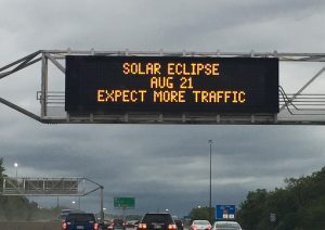
Eclipse traffic warning
“Thousands of people are expected to travel to St. Joseph to observe the eclipse,” said Dr. ZhiQiang Chen, associate professor of Civil Engineering at the University of Missouri-Kansas City. “It is expected that I-29 and U.S. 36 will be at a complete standstill during the eclipse. This will also create other traffic problems that could restrict emergency response efforts.”
Led by Chen, the drone project is a join effort between UMKC, and the University of Missouri Extension and University of Missouri-Columbia.
“It’ll be a game changer,” Chen said of the first-in-the-nation, community-based demo.
In a time of disaster, he explained, people won’t be able to rely wholly on a government response.
“One very unique feature about this demo project is that we are using assets from the community,” he said, noting Monday’s effort will rely on small business owners and hobbyists to pilot the drones.

At least six pilots are expected on hand 10 a.m. to 3 p.m. Monday to help observe the two locations — near the intersection of I-29 and U.S. 36, as well as at I-29 and U.S. 229, Chen said — with two vehicles flying at a time at each site. The solar eclipse is expected shortly after 1 p.m. across the metro.
Monday presents a valuable chance for researchers to test their collection methods and software in a disaster-like, real-time scenario, Chen said. The drone-based technologies are intended to assess damage and safety concerns, as well as the most effective access routes to persons in need of support.
“We are using the solar eclipse as the big stage to demo our technologies for emergency response,” he said. “I think it is the perfect opportunity for us because you rarely find similar disaster situations where you have a half-million people entering in one place.”
The team will use imaging drones and smart applications to send visuals to a remote cloud infrastructure for GIS (geographic information system) integration and advanced analytics as the drones are in the air, Chen said. Researchers hope it will help identify potential gaps in existing emergency planning efforts ahead of future disaster or emergency situations.
Featured Business

2017 Startups to Watch
stats here
Related Posts on Startland News
LISTEN: Ground Truth Ag puts real-time objectivity into grain grading; here’s how it makes your food safer
On this episode of our 12-part Plug and Play Topeka podcast series, we speak with Kyle Folk, CEO and founder of Ground Truth Ag — a next-gen ag-tech company using AI, machine vision and near-infrared spectroscopy to deliver real-time grain-quality data across the farm-to-market workflow. Folk shares how his upbringing on a Canadian farm inspired…
Peek inside: Buffalo State Pizza takes another slice of ownership with fresh-baked downtown OP relocation
Three decades of pizza at a popular downtown Overland Park corner might have come to a close this week, as the crew at Buffalo State Pizza Co. picked up the last of what they could carry and walked it a half block down the street to the shop’s new home near another local favorite, The…