
Eclipse watch: Drones to help UMKC-led researchers analyze gridlock
August 18, 2017 | Tommy Felts
")
With all eyes on the sky for Monday’s rare solar eclipse, the heavens will be watching back.
A team of volunteer drone pilots, research specialists and emergency management officials plan to use a fleet of unmanned aerial vehicles to provide real-time observation and analysis of Kansas City-area traffic at two likely congestion points during the much-anticipated astronomical event.
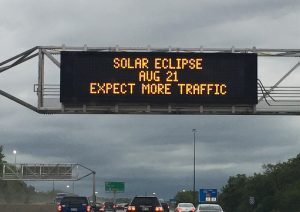
Eclipse traffic warning
“Thousands of people are expected to travel to St. Joseph to observe the eclipse,” said Dr. ZhiQiang Chen, associate professor of Civil Engineering at the University of Missouri-Kansas City. “It is expected that I-29 and U.S. 36 will be at a complete standstill during the eclipse. This will also create other traffic problems that could restrict emergency response efforts.”
Led by Chen, the drone project is a join effort between UMKC, and the University of Missouri Extension and University of Missouri-Columbia.
“It’ll be a game changer,” Chen said of the first-in-the-nation, community-based demo.
In a time of disaster, he explained, people won’t be able to rely wholly on a government response.
“One very unique feature about this demo project is that we are using assets from the community,” he said, noting Monday’s effort will rely on small business owners and hobbyists to pilot the drones.

At least six pilots are expected on hand 10 a.m. to 3 p.m. Monday to help observe the two locations — near the intersection of I-29 and U.S. 36, as well as at I-29 and U.S. 229, Chen said — with two vehicles flying at a time at each site. The solar eclipse is expected shortly after 1 p.m. across the metro.
Monday presents a valuable chance for researchers to test their collection methods and software in a disaster-like, real-time scenario, Chen said. The drone-based technologies are intended to assess damage and safety concerns, as well as the most effective access routes to persons in need of support.
“We are using the solar eclipse as the big stage to demo our technologies for emergency response,” he said. “I think it is the perfect opportunity for us because you rarely find similar disaster situations where you have a half-million people entering in one place.”
The team will use imaging drones and smart applications to send visuals to a remote cloud infrastructure for GIS (geographic information system) integration and advanced analytics as the drones are in the air, Chen said. Researchers hope it will help identify potential gaps in existing emergency planning efforts ahead of future disaster or emergency situations.

Featured Business

2017 Startups to Watch
stats here
Related Posts on Startland News

Check out the entrepreneur winners of this library pitch competition (and beyond-the-shelf resources)
Overwhelmed and excited to make a bigger impact, Rasheedah Villarreal expressed joy and gratitude Thursday after her name was announced as the top winner among a wide-ranging catalog of entrepreneurs pitching for cash prizes, community support, and serious momentum. Her business, Social Emotional Yoga with Mrs. V, also earned “Crowd Favorite” honors, sending the founder…
Controlled Burn: BoysGrow sets the table for fire-infused meal sparked by farm’s teen entrepreneurs, KC chefs
A live fire culinary event at the BoysGrow farm in south Kansas City is a dream come true for John Gordon, he shared, detailing plans for a fundraiser that harvests an immersive and unforgettable dining experience from the teen-focused ag entrepreneurship program. The one-night-only “Controlled Burn” heats up Oct. 5 at the 10-acre farm where…

BeVel’s edge on Troost: Scaling culture alongside barbershop’s executive clean up
A young Casie Murff jumped from cutting lawns to shaping lines, but it wasn’t until decades later — after embracing support from groups like The Porter House KC, Kansas City G.I.F.T. and a resurgent Troost business community — that the entrepreneur’s vision truly started buzzing. “Sometimes as entrepreneurs, you need that reassurance,” Murff, founder of…

Photos: Founders plug into vibrant Startup Crawl energy as Startland celebrates decade of storytelling
Startland News’ one-night, rolling innovation showcase Friday served as a launch for select founders — capitalizing on a crowd of 500-plus Startup Crawl participants to bring their emerging companies into the Kansas City spotlight, one conversation at a time. “I love that we got to share Portrayals XR with Kansas City first,” said Tricia Keightley,…